
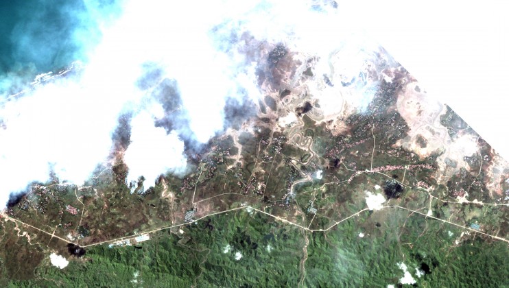
(New York, October 17, 2017) – Newly released satellite images reveal that at least 288 villages were partially or totally destroyed by fire in northern Rakhine State in Burma since August 25, 2017, Human Rights Watch said today. The destruction encompassed tens of thousands of structures, primarily homes inhabited by ethnic Rohingya Muslims.
Analysis of the satellite imagery indicates both that the burnings focused on Rohingya villages and took place after Burmese officials claimed security force “clearance operations” had ceased, Human Rights Watch said. The imagery pinpoints multiple areas where destroyed Rohingya villages sat adjacent to intact ethnic Rakhine villages. It also shows that at least 66 villages were burned after September 5, when security force operations supposedly ended, according to a September 18 speech by State Counselor Aung San Suu Kyi. The Burmese military responded to attacks on August 25 by the Arakan Rohingya Salvation Army (ARSA) with a campaign of ethnic cleansing, prompting more than 530,000 Rohingya to flee across the border to Bangladesh, according to the UN refugee agency.
Tuesday, 17 October 2017
Available in
Burma: New Satellite Images Confirm Mass Destruction
Related News

ENG
Monday, 12 October 2026
Philippines: Flood Control Project Disregards Rights
Pampanga Residents Face Flooding, Lack of Livelihoods at Relocation Site
ENG
KO
Tuesday, 8 September 2026
South Korea: Systemic Gender, Age Discrimination at Work
Widen Opportunities, Close Pay and Pension Gaps for Women

ENG
Monday, 18 May 2026
Myanmar: No Redress for Rohingya Muslims in Arakan Army Massacre
At Least 170 Killed at Hoyyar Siri in 2024 Amid Military Indifference; Survivors Denied Return